


Footsteps through time: hiking below the rim in the Grand Canyon
Part 2: My Grand Canyon Adventure Series

Re-connecting with the canyon, one trail at a time
Come along with me as I prepare for my Grand Canyon rim-to-rim adventure this October. In this post, I provide an overview of the historic foot paths below the rim.
Twenty years ago, my husband and I hiked rim to rim across the Grand Canyon -from the North Rim to South Rim. It was an epic journey, though I had no idea how deeply it would root itself in me. This October, I am returning - seeking clarity, healing and I hope - a deeper connection to the person I’ve become.
Read Part I of My Grand Adventure Adventure Series here: The Grand Canyon, Twenty Years Later: A Fresh Lens on a Legendary Landscape
For best viewing of this post, may I suggest using the Substack mobile/desktop app or view it in your browser. As this post is a bit long, Substack may truncate it when delivered to your email inbox.

A mountain upside down: hiking down and then up
Three main corridor trails carve a path into the heart of the Grand Canyon - each one distinct, yet all equally stunning, steep, and rugged. They promise breathtaking beauty, punishing climbs and the kind of awe that pulls you in and wears you out.
Hiking below the rim of the Grand Canyon is unlike any other trek. As seasoned Grand Canyon hikers say: going down is optional - coming back up is mandatory.
It is a a journey of descent - step after step into the depths - followed by a relentless climb back up to the top. This adventure demands not just strong legs and glutes, but a strong will. I would call it a physical and mental slog.
Going down and down and down and then up and up and up.
The Main Corridor Trails - the Bright Angel Trail
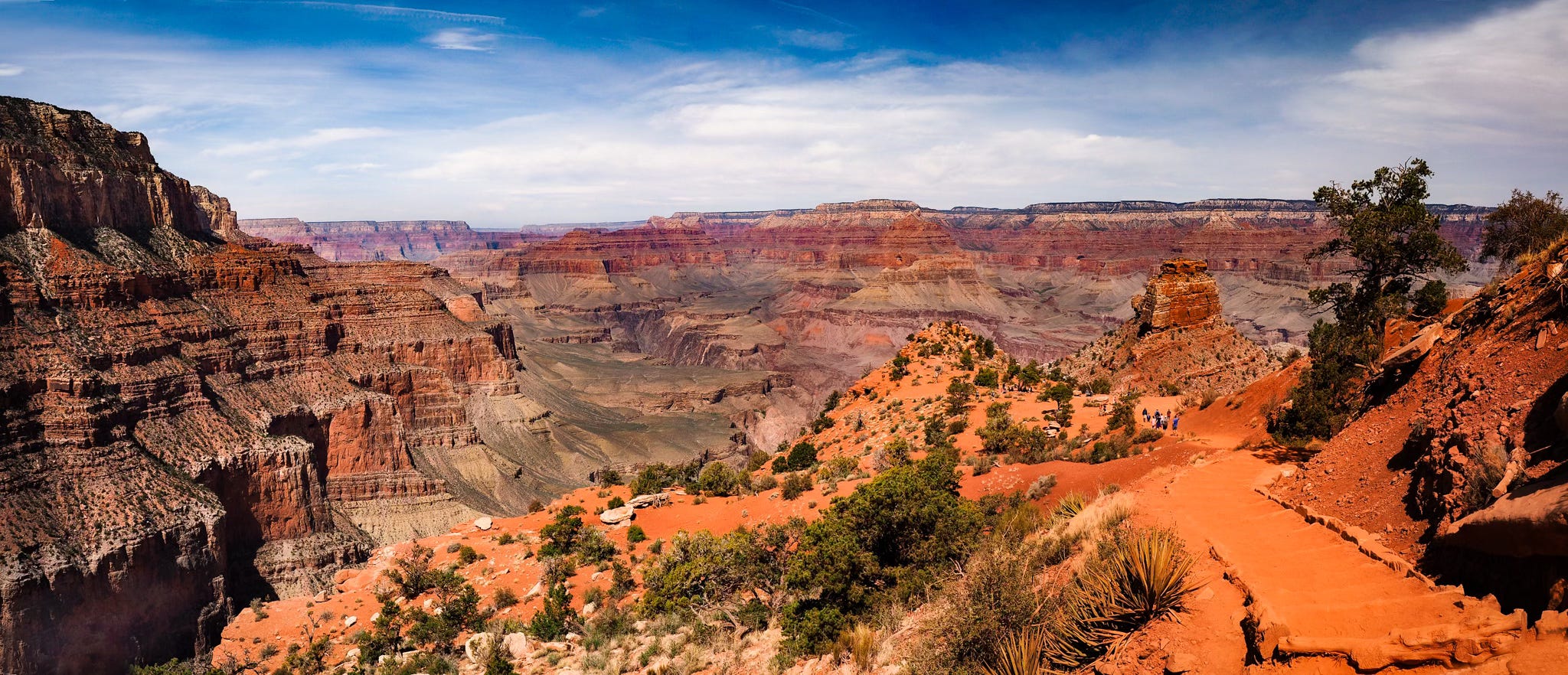
Probably the most heavily-used trail, the Bright Angel Trail starts near the heart of the Grand Canyon Village on the South Rim. The trail winds down into the canyon for about 8 miles where you reach the Colorado River at a place called Pipe Creek Beach.
A lot of ‘day-hikers’ venture down to the 1.5 mile Resthouse and back up to the South Rim. A total descent of about 1,120 feet for 1.5 miles.


Key points to know about the Bright Angel Trail
Trailhead at the South Rim, close to the Grand Canyon Village
Limited parking at the trailhead
Shuttle service available to the trailhead
Well-maintained trail and open all year (may be icy in the winter months)
No permit needed to hike this trail.
Water access at two points along the trail and at the campground.
Access to Havasupai Campground (overnight stays with permit)
Gradual descent and ascent (in comparison to the South Kaibab Trail) with shade areas available depending on the time of day
NOTE: Construction closures impact the use of most parts of the Bright Angel Trail in 2025: the trail is closed from the South Rim to the Tonto Trail until October 1, 2025.
Below is an excellent overview video of hiking the Bright Angel Trail:
Historical (and timely) significance of the Bright Angel Trail
The Bright Angel Trail traces an ancient route used by the Havasupai people for centuries, connecting them to water, farmland at Indian Gardens (now Havasupai Gardens) and other parts of the canyon.
The Havasupai people have lived in the Grand Canyon for over 800 years.
In the late 1800s, a business man named Ralph Cameron took over the trail primarily to develop mines. He turned it into a toll route for tourists, essentially blocking public access and sparking legal battles for years with the Federal government.
In the 1920’s, the National Park Service reclaimed the trail, marking a shift from private control to public access and preservation.
Visit my Substack at Outdoors with Jenn for easy access to all my posts.
The Main Corridor Trails - the South Kaibab Trail
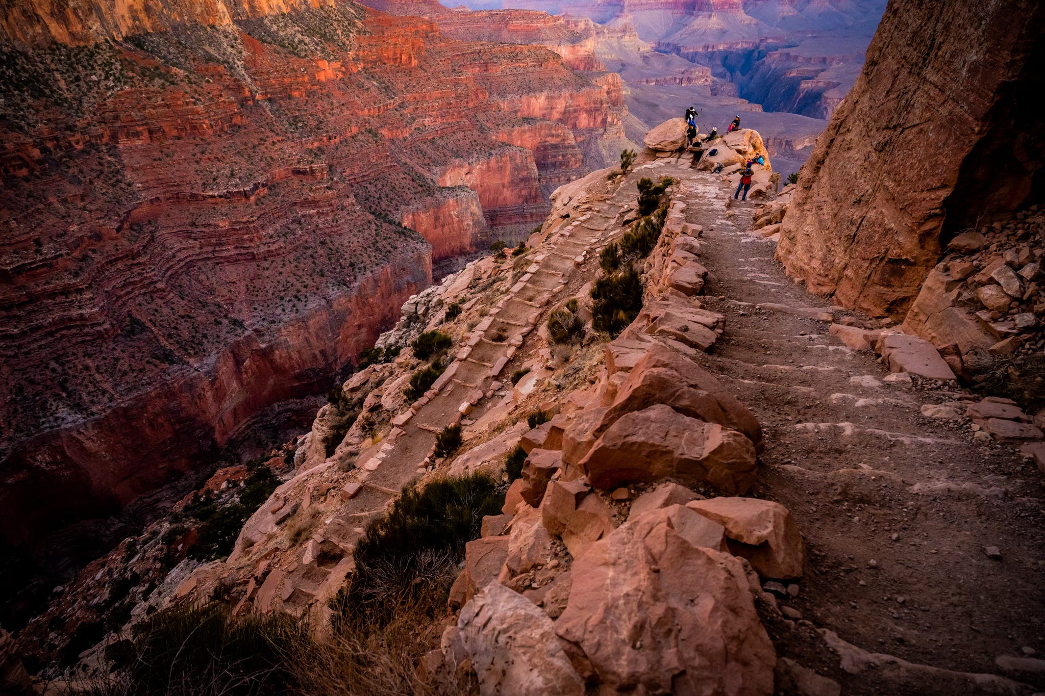
If you could hike only one trail in the Grand Canyon, let it be the South Kaibab. Blasted into the canyon walls in the 1920s by the National Park Service to build a public trail, it is much more than a route - it is a masterpiece of grit and vision.
This iconic, awe-inspiring descent takes you on a journey through geologic time, with every switchback offering sweeping views and soul-stirring beauty you’ll never forget.
A lot of ‘day-hikers’ venture down to Ooh Aah Point (photo at beginning of this post) and back. A total descent of about 1,120 feet for 1.5 miles.
Key points to know about the South Kaibab Trail
Trailhead at the South Rim
Shuttle service available to the trailhead
No parking at the trailhead
Well-maintained trail and open all year (may be icy in the winter months)
No permit needed to hike this trail.
No water access on the trail
Steep descent and ascent with no shade available
Historical (and timely) significance of the South Kaibab Trail
The South Kaibab Trail stands as a symbol of public access to national parks because it was built for the primary goal of offering a toll-free trail to the public. In a sense, its creation marked a shift in policy in the 1920’s - from private entities towards public stewardship and equitable access to our public lands.
Here is a visual of hiking up the South Kaibab - courtesy of Brian Speciale of the Grand Canyon Hikin Dude Show.
The Main Corridor Trails - the North Kaibab Trail
Climbing up the North Kaibab Trail to the North Rim is tough - the switchbacks cut into the red canyon walls seem endless and the steep grade never really lets up.


A breeze from nearby Roaring Springs gives you a short break, but the climb keeps coming. As the walls close in and the rim still feels far away, every step tests your legs, your lungs, and your grit. If you have time, take a short side-trip to Ribbon Falls where you can soak in the cool water.
Key points to know about the North Kaibab Trail
The only main corridor trail that originates at the North Rim
Campground available near the trailhead (backcountry permit not needed)
The North Rim typically closes for the winter season on October 15 but after this date, the area may be accessible for day use, depending on road conditions.
When the North Rim is closed , hikers can still hike up North Kaibab to the North Rim from the Phantom Ranch.
Well-maintained trail but can be snowy and icy in the winter
No permit needed to hike this trail.
Shuttle service (private) available to the trailhead and nearby lodging, with limited service in the winter months.
During the open season, water sources available at the trailhead, Supai Tunnel, Manzanita Rest Area and Cottonwood Campground. Water also available to filter from Roaring Spring.
Cottonwood Campground at 6.8 miles down (backcountry permit required) from the North Rim Trailhead.
Steepest ascent and descent of the main corridor trails.
A lot of shade available depending on the time of day.
Historical significance of the North Kaibab Trail
The North Kaibab Trail follows a route originally used by the Paiutes and the Havasupai peoples - to access water sources.
In the 1920s and 1930s, the Civilian Conservation Corps improved the trail, carving it into the canyon walls as part of a New Deal project.
Roaring Springs, located along the North Kaibab Trail, is the primary water source for much of Grand Canyon National Park.
A trans-canyon pipeline carries water from Roaring Springs to Phantom Ranch, the Bright Angel Trail and all the way to the South Rim.
Here is a visual of hiking down the North Kaibab - courtesy of Brian Speciale of the Grand Canyon Hikin Dude Show.

Thank you for your likes and re-stacks (sharing). If this information resonates with you, please tap the 🧡 button above to help others discover Outdoors with Jenn.
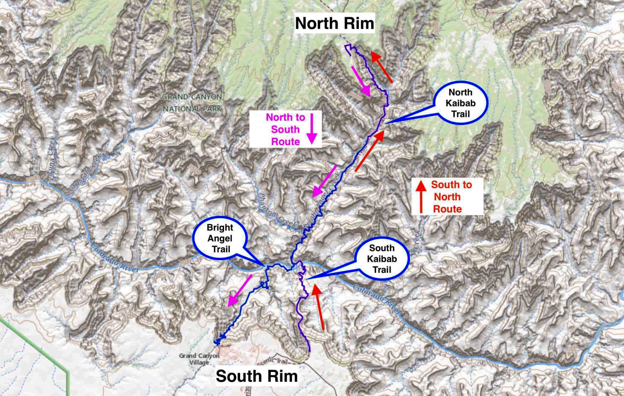
Which route should I take this October to hike rim to rim?
The two most popular routes to traverse the canyon are to hike it:
From the South Rim - down the South Kaibab Trail and then take the North Kaibab Trail to the North Rim.
From the North Rim by taking the North Kaibab Trail to Phantom Ranch and then take the Bright Angel Trail to the South Rim.
NOTE: Construction closures impact the use of most parts of the Bright Angel Trail in 2025: the trail is closed from the South Rim to the Tonto Trail until October 1, 2025.
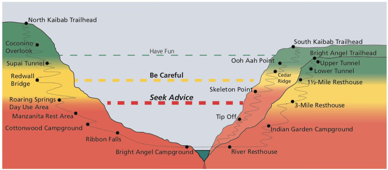
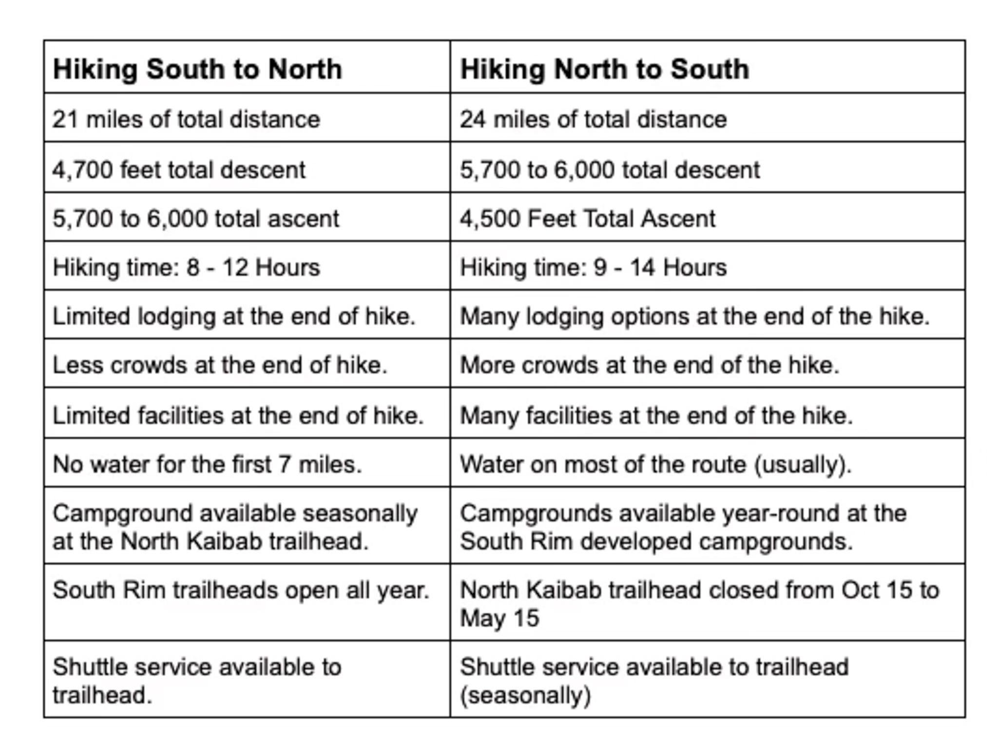
Here is a comparison chart I developed to help me make an informed decision on the best route to take to hike the Grand Canyon rim to rim.
Using YouTube videos to visually experience the trails in advance
I use YouTube (or similar) videos to get a sense of what to expect on the trails. Also, I read personal accounts provided by recent hikers (available through private social media groups) to gain more knowledge of the trails, the pitfalls and what to expect.
Here is a visual of hiking rim to rim in both directions - courtesy of Cris Hazzard, a license professional guide based out of California.
Stay tuned to find out what route I plan to use to conquer the canyon in October!
Upcoming posts in my Grand Canyon Adventure Series
Logistics of planning a point-to-point hike (which direction to take, lodging, shuttle arrangements, time of year and more)
The dangers of hiking below the rim of the Grand Canyon and how to be safe
The gear I plan to take (pack, clothing, communication, trekking poles, safety)
My training and preparation (hikes, strength training, heat prep)
Nutrition and hydration (food, electrolytes)
Resources
National Park Service - Grand Canyon - excellent resource for up-to-date trail conditions and water availability
National Geographic: Grand Canyon North and South Rims Topographic Map - the best paper-based map to have.
Previous post(s) in my Grand Canyon Adventure Series:
The Grand Canyon, Twenty Years Later: A Fresh Lens on a Legendary Landscape

Twenty years ago, in 2005, I dropped down into the canyon with my husband for an epic backcountry backpack adventure across the Grand Canyon - from the North Rim to the South Rim.

Outdoors with Jenn is always free, but if I wrote something that resonates with you, I am happy to accept a cup of coffee. Thank you for reading.


Definitely on my bucket list to see one day. Would love to try that South Kaibab trail you mention, Jenn. Looking forward more updates on how your upcoming adventure to the Grand Canyon in October.
Love it! Think it’s been close if not over 40 years for me….